|
|

|
I am interested in the area of Cloud computing and mobile devices. My interest is
particularly focused on combining public and private Clouds to form a hybrid Cloud
to support mobile devices. The level of support is adaptive and varies based on the
sorrounding context and deployment policy.
I have also worked in the area of indoor localization. I developed stable algorithms for reliable indoor
localization for mobile devices using existing infrastructure. The required infrastructure can be
adjusted based on existing platforms and can varry from RFID cloud to wireless Access Points. We later used
the system in our emergency response rescue project.
I have also been involved in the area of wireless sensor network and its application for structural
health and environmental
monitoring. The focus was on the problem of energy saving in wireless sensor network
with respect to the required level of time synchronization.
I also have experience in the area of real-time visualization. I combined visualization techniques with wireless
sensor networks to create a real-time visualization of construction equipment emissions with emphasis on Green-House Gases (GHGs).
In this page, I try to summarize
the projects I have been involved in over the past few years. Many of them are in
collaboration with different organizations, universities and people. I would be more than
happy to provide additional information, if needed. I would also appreciate any suggestion or comment on any of the ideas or
the approaches.
|
|
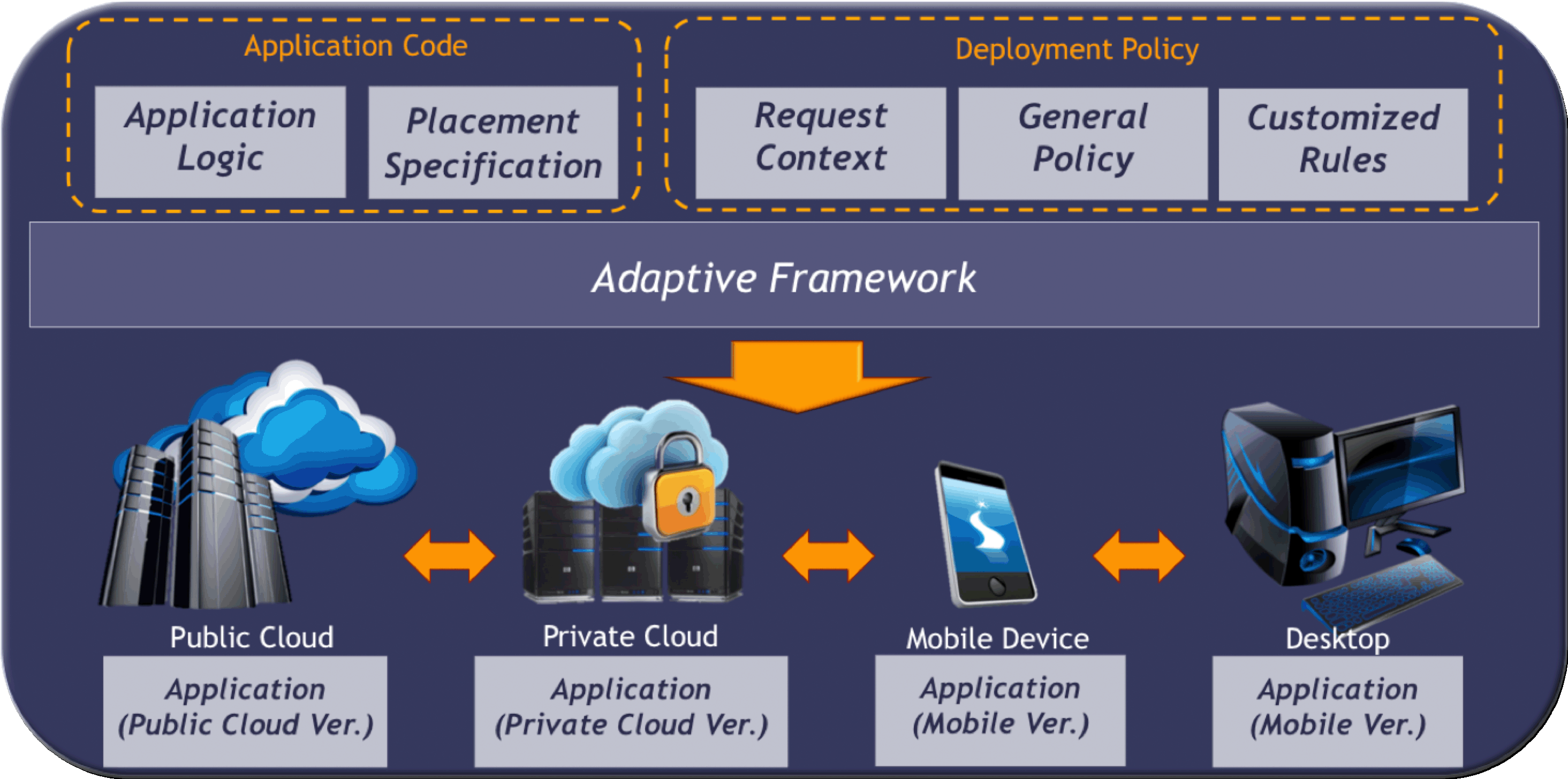
1) An Adaptive Programming Framework for Mobile-Cloud Applications:
This is my ongoing project and I would add more details as soon as our papers are published. Meanwhile,
you can have a look at the figure below which shows the high level overview of the framework.
Programming at a higher level of
abstraction enables adaptive deployment over heterogeneous platforms.
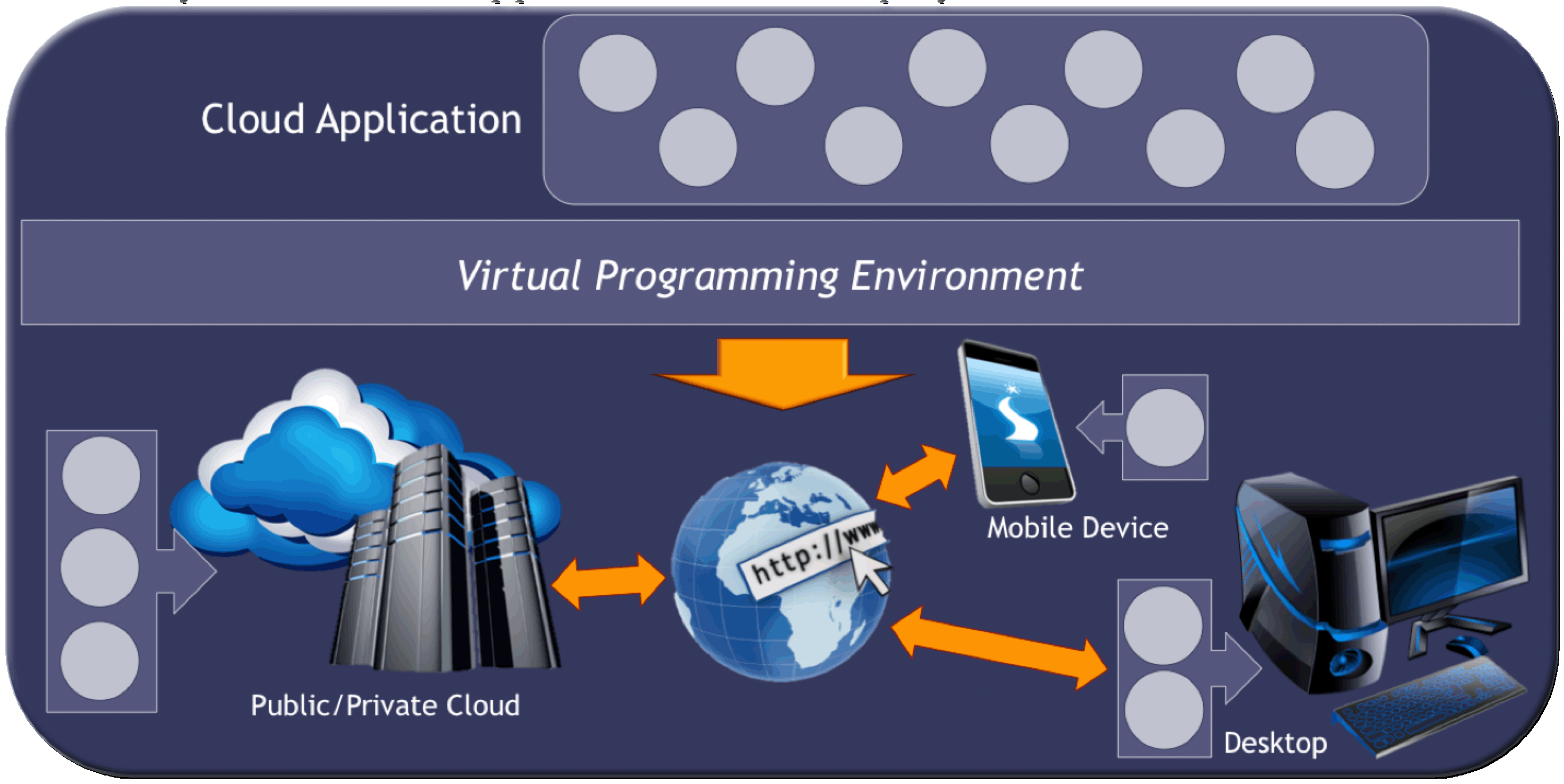
Source-to-source translations: Depending on the deployment policies and the request context,
the framework translator implements application objects using different technologies including
public Cloud version, private Cloud version, mobile device version, and desktop version.
We have several ongoing publications on this poject. I would add them here as soon as they are out.
- "An Adaptive Programming Framework for Cloud Applications", poster, The 5th IEEE/ACM International Conference
on Utility and Cloud Computing, Chicago, Illinois, Novemeber 5-8, 2012.
|
|
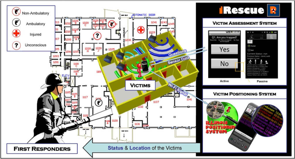
2) iRescue: Bio-inspired Emergency Responce Project:
This is a cross-disciplinary project that draws inspiration from biological
systems to help design wireless sensing and communications networks to
aid emergency responders in rescuing victims after a disaster. The project
is currently focused on how to quickly and efficiently get useful information
to first responders about the status and location of the individuals trapped
inside a building.
In general, first-responders have no way of sensing the presence of trapped
individuals. But today, even in poorer countries, almost everybody carries a
cell phone. Cell phones are getting more sophisticated every year, with
dozens of onboard sensors (camera, microphone, GPS, gyroscope, accelerometer,
etc.) and support for multiple wireless communications protocols (cellular,
Wi-Fi, Bluetooth). Our idea is to use individual
smartphones inside a building as a distributed wireless sensing network.
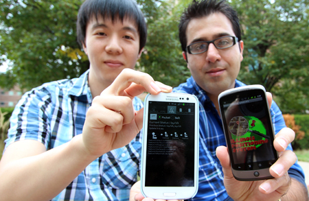
We have been developing a prototype system called iRescue, short for Illinois
Rescue:
- Following a disaster, a smartphone application could be launched automatically
to assess the status of a user via on-screen questions. We have also developed
an application that automatically uses the smartphone’s sensor data to assess
the likely status of its owner. Using accelerometer and gyroscope sensors,
which act much like an animal’s vestibular system, the smartphone can monitor
its own motion and determine what may be happening. Using a Bayesian classifier
system, which is similar to how the brain processes noisy and uncertain sensory
data, we successfully recognized nine different activity patterns (e.g., sitting,
standing, walking, running, etc.) with 90% accuracy. The system can also distinguish
between a cell phone on a desk or in a drawer from one that is being carried by
an individual.
- We are currently working on an indoor localization system that can
estimate each smartphone’s location in the absence of GPS signals that don’t
penetrate into the building . Status and location information from individual
smartphones could then be communicated wirelessly to a tablet-like device
carried by first responders, providing them with an overview of the current
situation.
Figure below shows the high level overview of the system:
Fortunately, the project has received wide coverage from the media. Here below you can
find WCIA 3 channel covering the project in its News at 10:00 program:
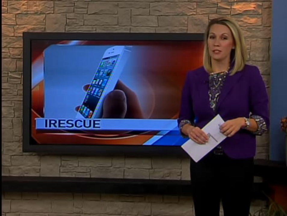
Moreover, here is the link to our project covered in the University of Illinois -
College of Engineering newsletter:
I will soon add our publications in this regard as well. Meanwhile,
you can refer to the
project page for more information through here .
|
|
3) GEM: Green-house gas Emission Monitoring:
Air pollution has been a challenging problem all around the world for more
than two decades. The effect of excessive amount of chemicals and particulate
materials (pm) in the air on human health has been known for many years.
However, in many small and large cities around the world, individuals have to
live in direct contact to the polluted air for long period of time. The result
is significant increase in the mortality rate and the rate of people suffering
from diseases relate to air pollution, i.e. different types of cancers,
allergies, bronchitis, etc.
On the other hand, due to the excessive amount of
human-made Green House Gas (GHG) emissions, global warming and climate change
have also been intensified in recent years. The latter has affected lives of
many by increasing the frequency of happening and severity of natural disasters
all around the world in recent years. According to the EPA (2011), the Earth’s
atmosphere average temperature has increased about 1.3şF over the last century
and if the current trend of GHG emission continues, the increase would reach
more than 5şF by the end of this century.
Studies have highlighted transportation sector as the second largest contributor of GHG,
PM and other emissions, which is responsible for more than 30% of total annual
emissions. As part of the effort to reduce GHG emissions from this sector,
this project is focused on developing a framework for measuring, monitoring,
and controlling construction equipment emissions.
Wireless sensor networks (WSNs) are widely used these days in many projects for
environmental purposes. Our effort is focused
on developing a framework for monitoring and visualizing the GHG emissions from
the construction equipments in real-time using wireless sensor networks. Our vision
is that existing or added wireless sensors combined with an indoor-outdoor location tracking system
and visualization techniques can be used as a potential and currently untapped
source of information to support and improve construction emission reduction
programs.
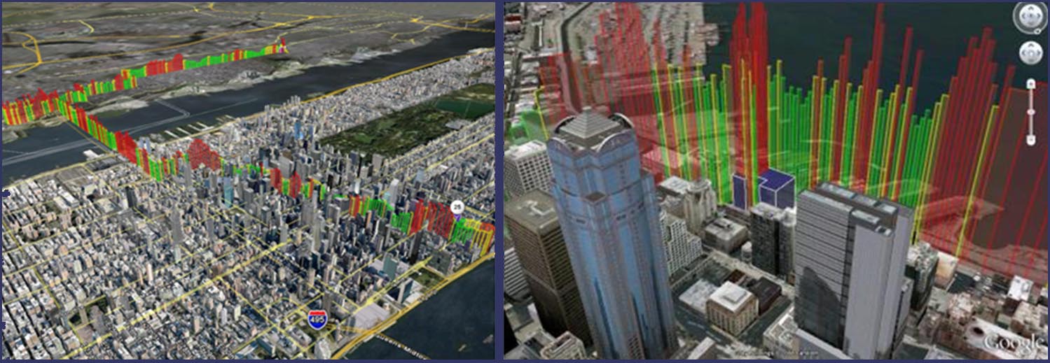
Figure below shows the overview of our developed framework where emissions are
estimated using computer simulations, measured on-site using wireless sensor networks,
controlled with the regulated values, and visualized to summarize the analysis results.
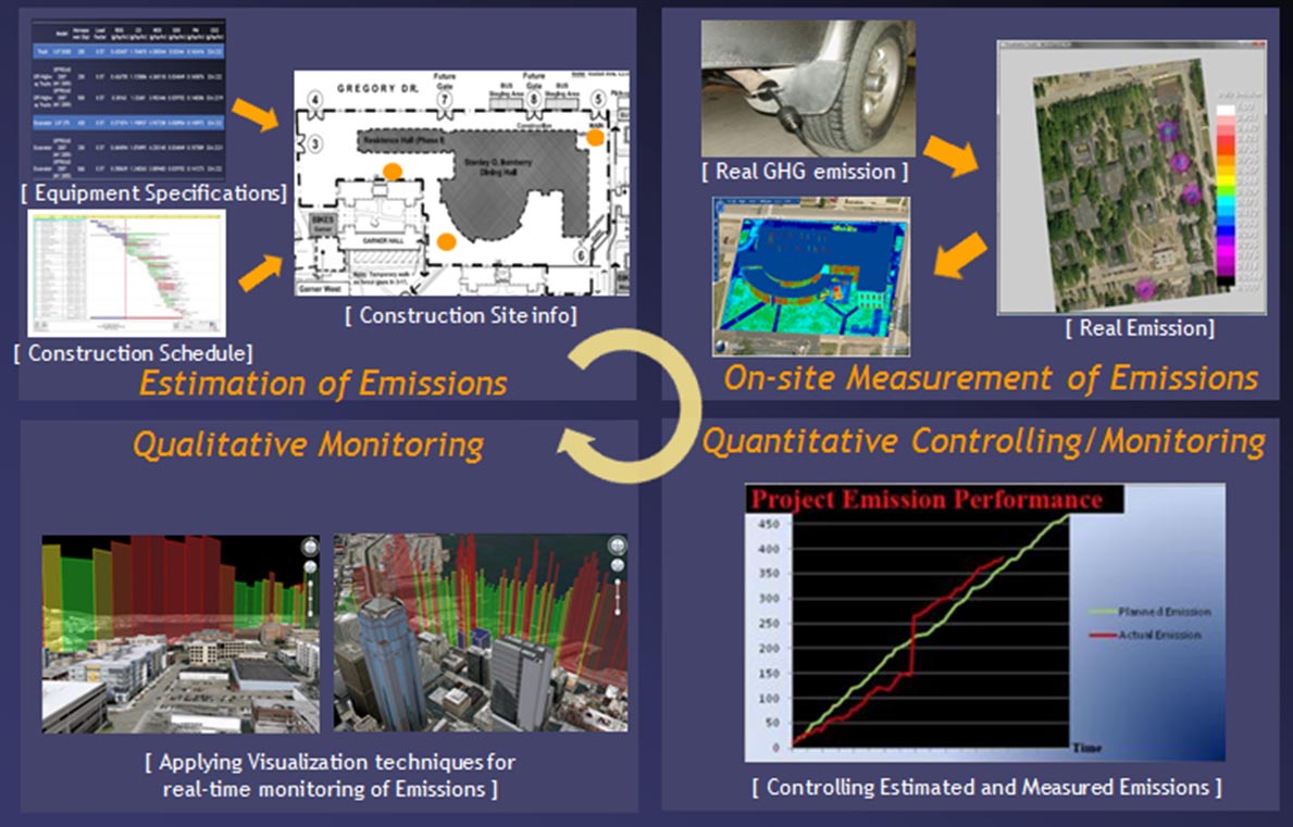
The following figure further shows the real-time 3D visualization of a concrete-mixing transportation
truck to and away from the construction site. Colors represent real amount of emissions
in comparison to the estimated or regulated values.
For further study of the topic, you can refer to our project page at
Here .
Please note that you need to install the Google Earth Plugin to be able to see the 3D
visualization.
We also have several publications on the topic indifferent journals and conferences. Some of these
publications are listed below:
- "An Integrated Framework for Quantitative and Qualitative Monitoring of Construction
Equipment Emission", Canadian Society of Civil Engineering (CSCE), Leadership in sustainable
infrastructure, Edmonton, Canada, June 6-9, 2012.
- "Application of Visualization for Construction Emission Monitoring”, Innovation for
Reshaping Constr. Practice, CRC 2010, May 8-11, Alberta, Canada, 2010.
- "Construction Emission Monitoring System”, The international conference on Computing
in Civil and Building Engineering (icccbe), Nottingham, UK, June 30- July 2, 2010.
- “Construction Equipment Emission Monitoring System - Opportunities, Benefits & Challenges”,
6th International Conference on Innovation in Architecture, Engineering and Construction (AEC)
, State College, Pennsylvania, June 9-11, 2010.
|
|
4) Indoor Localization System:
to be added soon
|
|
5) Time Synchronization and Energy Saving in Wireless Sensor Networks:
Saving energy is one of the principal challenges in wireless sensor networks.
Dynamic voltage and frequency scaling (DVFS) is often used to reduce energy
consumption in systems where sleep is not an option.
We saw that changing the CPU
frequency of a wireless sensor node introduces sudden changes in clock behavior, thereby affecting the
time-keeping functionality. This anomalous phenomenon is observed in different
sensor platforms and causes a loss of time synchronization among nodes that
is unacceptable to applications such as structural health monitoring that require
tightly synchronized clocks over extended periods.
Our research studied the problem of energy saving in wireless sensor networks using dynamic
voltage and frequency scaling technique. We investigated the effect of DVFS on required
time-synchronization . Our effort provides experimental measurements of the clock value shift anomaly in
three widely used wireless sensor platforms and its impact on clock synchronization
costs. A general framework balancing the need to save energy against the need to
keep clocks synchronized is developed. Our system is implemented and evaluated on a
network of sensors deployed on a truss bridge and running a high-fidelity structural
health monitoring application. Experimental measurements confirm the efficacy of the
solution in saving energy while maintaining an acceptable level of synchronization.
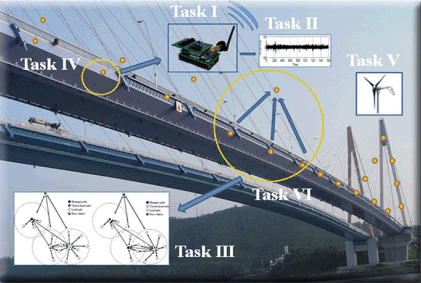
Figure below shows
typical application of dense Wireless Sensor Network (WSN) deployment to continuously
monitor the state of civil infrastructure for damage or deterioration. The Structural
Health Monitoring work is motivated by unreliability of visual inspection and high cost
of wired solutions:
Although in theory the problem of
DVFS and time-synchronization can be summarized into an optimization problem, in practice it
is too computationally complex to be solved locally at WSN nodes. Instead we used a hybrid
controller to solve the problem. In fact, we profile the application and precompute controller
parameters offline and during the training phase. This leads to minimal overhead for the online controller
to reach optimal scheduling policy. Figure below shows our hybrid controller implementation:
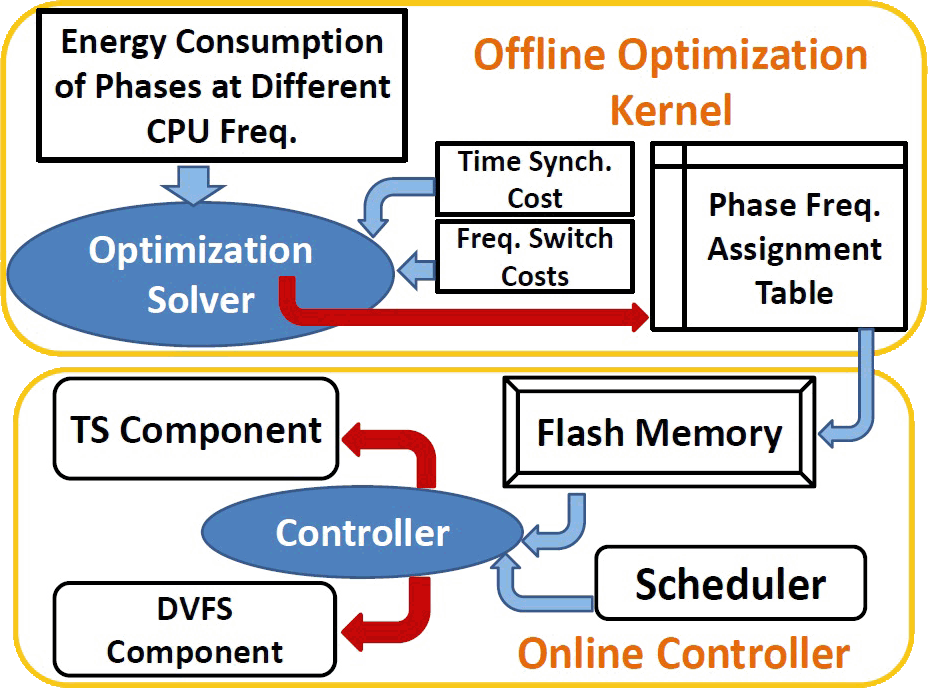
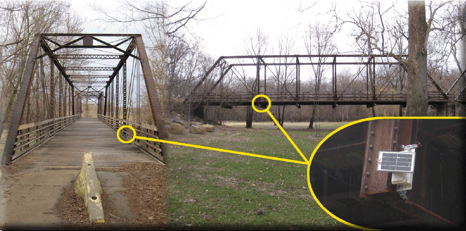
Figure below shows our experimental testbed. It is a truss bridge over the Sangamon River in Illinois.
As can be seen in the picture, solar panels are used to charge the batteries which leads to a long-lasting
wireless sensor network:
I have more information on this project in my weblog. But
for further study of the topic, you can refer to our paper
in this regard. The paper has won the BEST PAPER AWARD from SECON 2012 :
- "The time-keeping anomaly of energy-saving sensors: manifestation,
solution, and a structural monitoring case study", IEEE Communications
Society Conference on Sensor, Mesh, and Ad-hoc Communications and Networks
SECON), 380–388, IEEE, Seoul, Korea, June 18-21, 2012.
|
|
|